|


|
|
|
|

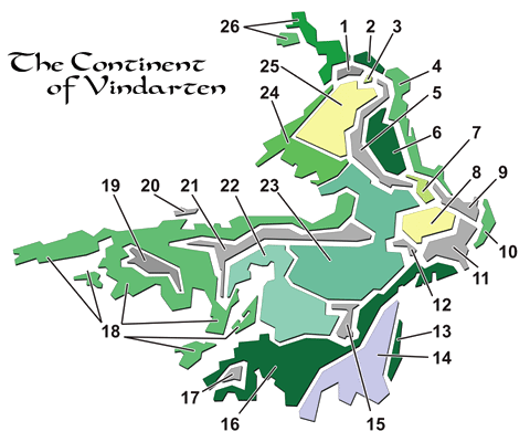
The following exploded terrain/climate map of
Vindarten outlines the distinct differences in the various major geographic
regions of the continent. All rivers, lakes, inland seas, and other bodies of
water have been omitted for clarity.
Each numbered region label is clickable and
will take you to the corresponding description of that region.
|
- The dry Mountains
of Chult in the north are ice-capped but with little vegetation, except
along water courses. These peaks average about 8,000 ft. in height.
- The twisted, monstrous
jungles of the Were separate the jungles of Chult in the north
from the Eastersea Confederacy in the south. This area, ravaged by the
Mage Wars some 1400 years ago, is home to massive, buttress-trunked emergents
growing more than 500 ft. tall. The wilds of the Were host animals (and plants)
so fierce and deadly that travellers journey between walled cities on stone
causeways in armored wagons.
- The Break is a
wide pass between the Catheral Range in the south and the Mountains
of Chult in the north. It is a paradise for herd animals.
- The coastal region
occupied by the polities of the Eastersea Confederacy ranges in climate
from subtropical in the north to temperate in the south. The region is
agriculturally rich and supports a strong coastal fishing industry.
- Ranging up to 14,000
ft. high in the north, the Cathedral Mountains are a heavily weathered
parallel granite range. They are dry in the west, but wetter and heavily
forested with conifers in the east.
- Ordinarily damp and
warm, this region is very much like the U.S. state of Alabama. It offers thick
pine forests and rich soil for farming.
- The savannah of
Kalishan is a buffer between numerous climatic regimes; its year-to-year
weather is widely variable.
- The Barr
al-Fadi (and the Pit of Karag at its heart) is the most desolate
place on the continent. Most of the Pit is dune, broken by occasional stretches
of Reg, or rocky desert. Only along the rivers can vegetation be found.
The oases are few and far between. In summer, temperatures can exceed
115°.
- The mountains of the
Wild Coast are cooler granitic structures, with mixed forests covering
their slopes. The average height is 8,000 ft.
- The coastal region
east of the Pillars of the Sky consists of moist lowlands; an excellent
area for farming.
- The Pillars of the
Sky border Barr al-Fadi on the south. They are uniform strata,
mostly limestone, recently uplifted. This region has been fractured and eroded
into thousands of mesas, some as high as 12,000 ft. in the northeast, down to a
more moderate 7,000 ft. in the southwest. The coastal (southeastern) face is
karst terrain, riddled with watery sinkholes and caves.
- The westernmost tip of
the Pillars is older granite, rather than limestone. It is sharpely
eroded and very dry.
- The narrow eastern
coast of Perrinland and Borea consists of thick pine forests.
Normally cool and dry, it receives much snow in the winter.
- The interior reaches
of Perrinland and Borea are also cool and dry, but the region
supports fewer trees. Grasses and lichens abound. The enormous marshes to the
south support vast bird populations during summer nesting. The winters are cold
and, like the coast, receive a great deal of snow.
- The Storm
Range, which forms Perrinlands west border, is of mixed composition.
Mostly granite in the south, the northern portions consist of newer basalt.
Average summit heights are 8,500 ft., with glaciers on the higher
peaks.
- Trondheim is
covered in pine forests. Stately and dense in the north, they dwindle to a
ragged and puny covering in the southern regions of Stavanzer. The
region is uniformly cool in the summer and frigid in the winter.
- The looming Mt.
Jonkinverhengittää ("Jon-kin-ver-hen-GEETA") is an ancient
shield volcano, sloping gradually up to over 24,000 ft. at the lip of its
vast crater. The interior of the dormant peak slumps to roughly 10,000 ft.
and is warmed by countless volcanic vents and hot springs. Shielded by the
fortress-like crater wall, isolated region covers several hundred square
miles and is home to a wide variety of bizarre plant and animal
life.
- The western lands of
Kel, Ord, Zemlya, and Starfjorden consist of
rolling, forested hills and plains, moderate in rainfall, with goods soils and
a generally argeeable climate. The off-shore islands are, with very few
exceptions, equally pleasant. The far southern regions get snow in the winter,
save for the coastal areas, which are warmed by a easterly ocean current.
Hurricanes are an occasional hazard along the northern coast.
- The West Range
is the most chaotic of all the mountains across Vindarten. It is
presently volcanic, but the volcanism is occurring in uplifted and contorted
depositionals. The central area is mostly karst formations.
- Nokobi Island
is a bleak granite slab covered with birds, bird nests, and bird droppings. A
breed of carnivorous emu-like bird is the dominent life form and mammals have
never taken hold save for a few small rodents. The birds feed on the teeming
sealife of the banks to the north.
- The Sindarin kingdom
of Ardenor is surrounded by a high granitic range, fractured at several
points. With an average height of 10,000 ft. both north and south, these
mountains provide the "Thousand-Mile Valley" with natural
fortress walls. The southern spur is actively volcanic at several points. The
northern spur is quiet and has some local glacier activity.
- The cool, wet climate
of Karajosk supports mixed deciduous and fir rain forests. While the
soil is very fertile, open areas for agriculture are small and scattered.
Wildlife, on the other hand, thrives in the dim woodland interiors.
- The Kahliopsis
in the south, and Amshir in the north, are covered by high grassy
plains. Portions are lightly forested, as are all of the watercourses. At the
southern border of the Kahliopsis, the divisive Edge of the World
scarp and the Great Canyon affect the altitudes involved by several
thousand feet. The interiors of the Great Canyon are warmer, frequently
foggy, and can support extensive farming. The Edge of the World drops
vertically almost 4,000 ft. from the rim of the Kahliopsis to the
forests of Perrinland in the east, and the rolling hills of
Karajosk in the west.
- The eastern coastal
region of Delowah sees frequent morning fog, but scant rainfall. Between
the latitude and the warm onshore ocean currents, the year round temperatures
are high, even on the coast. In areas where water is available, farming is
productive. Many small communities florish in the low hills that parallel the
north coast, and many take advantage of the excellent ocean fishing.
- The Rigga
Desert is partially bounded on the south by the dead Lake of Amshir
(which is actually an inland sea). Occasional large storms sweep over this
area, making flash floods a frequent threat. The terrain is mostly rolling
hills, canyons, and pans; there are almost no sand dunes.
- The long stretch of
jungles and mountains that comprise Chult are uniformly wet and lush.
The mountains are relatively low (not reaching above 8,000 ft.) but consist of
very rugged, knife-edged basalts.
Return to top of page.
Last
updated on 7 November 2014.
|